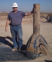
The following is a series of pics of the New River, in SoCal, it is now the primary drainage for an intermontain basin created by the San Andreas Fault system, the fault has been quiescent the last few weeks, must be getting ready to party, it normally has 3 or 4 small quakes a day out here, any way, the new river and its channel are named appropriately(there is a reason for that), periodically, the Colorado River would breach the barrier between its current drainage and the imperial valley, the basement rocks of the IV are many thousands of feet below current ground level, and each flood into the iv would bring sediments and water, leaving mud and sand, and then an evaporite deposit as the inland sea dried out, in 1900 they started the canal systems out here to irrigate this VERY dry desert area, raising most of the US's current winter veggies, in 1905 a flood breached the head gates of the canal system and it took engineers, and railroad money, and two years to get it back under control, by that time the Colorado flooding into the valley had formed the Salton Sea, also, the water created its own drainage channel to do this, ie, the "New River" was formed, the New River now provides drainage for the irrigation systems, and effluent from Mexicali, Mexico(about 1 million people), and leachate from several landfills, needless to say it is currently one of the most polluted rivers in the US, you can see people fishing in the canals all the time around here, but NEVER in the river.


No comments:
Post a Comment